
Fitxategi:Plan Nicholsona.jpg
Bereizmen handikoa ((6.092 × 4.849 pixel, fitxategiaren tamaina: 8,25 MB, MIME mota: image/jpeg))
Fitxategi hau Wikimedia Commonsekoa da. Hango deskribapen orriko informazioa behean duzu. |
Laburpena
| Egilea |
Drawn by
|
|||||||||||||||||||||||
| Deskribapena |
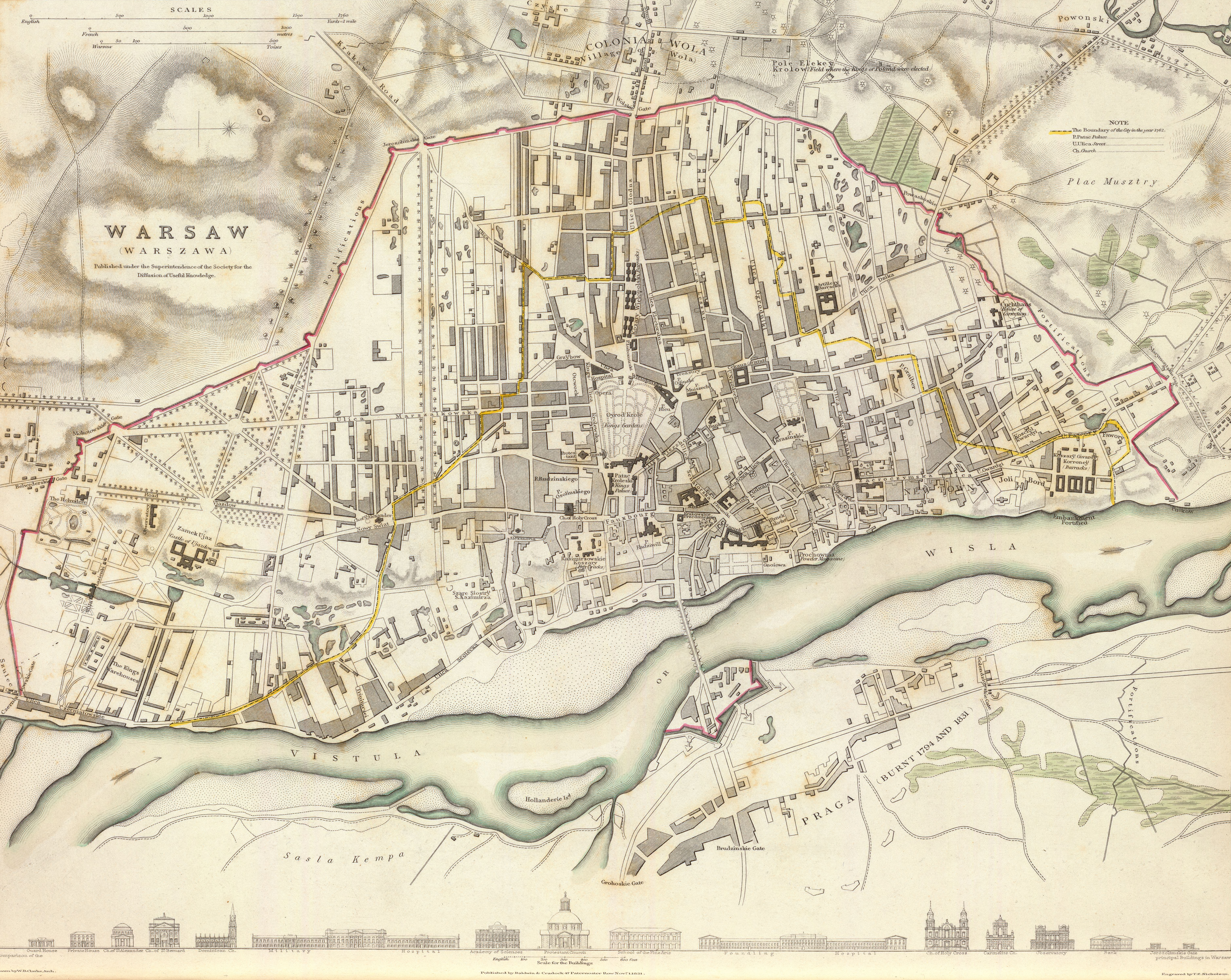
English: 1831 map of Warsaw, Poland, the so-called "Nicholson's Plan"
Note that the map is neither very accurate in terms of precision [1] nor in proper place names. Many if not most have been misspelt (Oyrod Krole park should be Ogród Królewski, Kozary Wielopolski (six buildings to the north of the park) should be called Koszary Wielopolskie, Cekauz (Arsenal) => Cekhauz, Patac Kroleski => Pałac Królewski and so on). Downloaded from David Rumsey's site ([2]), converted from .sid to .tiff format with mrsidgeodecode and then to .jpg with Adobe PS.Polski: Plan Warszawy z roku 1831, tzw. Plan Nicholsona
Plan jest względnie niedokładny, zarówno jeśli chodzi o precyzję jak i nazwy własne[3]. Wiele z nich zostało przekręconych (na przykład "Oyrod Krole" zamiast "Ogród Królewski", "Kozary Wielopolski" w miejsce "Koszarów Wielopolskich", "Cekauz" zamiast "Cekhauz", "Patac Kroleski" zamiast "Pałac Królewski" itd.). Mapa pobrana ze strony Davida Rumseya ([4]), przekonwertowana z formatu .sid do .tiff za pomocą mrsidgeodecode, a następnie do formatu .jpg z użyciem Adobe Photoshop. |
|||||||||||||||||||||||
| Data | 1831ko azaroaren 1ea | |||||||||||||||||||||||
| Teknika | engraving | |||||||||||||||||||||||
| Neurriak | altuera: 30 cm; Zabalera: 38 cm | |||||||||||||||||||||||
| Inscriptions | Published under the superintendence of the Society for the Diffusion of Useful Knowledge. Drawn by W.B. Clarke, archt. Engraved by T.E. Nicholson. Published by Baldwin & Cradock, 47 Paternoster Row, Novr. 1, 1831. (London: Chapman & Hall, 1844) | |||||||||||||||||||||||
| Jatorria/Argazkilaria | [5] | |||||||||||||||||||||||
| Beste bertsioak |
|
|||||||||||||||||||||||

Lizentzia
|
Lan hau jabetza publikoan dago bai bere jatorrizko herrialdean, bai egile eskubideak egilea hil eta 100 urtera edo gutxiagora iraungitzen diren gainerako herrialdeetan. | |
| This file has been identified as being free of known restrictions under copyright law, including all related and neighboring rights. | |
This work is in the public domain in the United States because it was published (or registered with the U.S. Copyright Office) before January 1, 1929.
Public domain works must be out of copyright in both the United States and in the source country of the work in order to be hosted on the Commons. If the work is not a U.S. work, the file must have an additional copyright tag indicating the copyright status in the source country.
Note: This tag should not be used for sound recordings. |
| Annotations | This image is annotated: View the annotations at Commons |
Fitxategiaren historia
Data/orduan klik egin fitxategiak orduan zuen itxura ikusteko.
| Data/Ordua | Iruditxoa | Neurriak | Erabiltzailea | Iruzkina | |
|---|---|---|---|---|---|
| oraingoa | 01:30, 18 iraila 2011 | | 6.092 × 4.849 (8,25 MB) | Halibutt |
Irudira dakarten loturak
Hurrengo orrialdeek dute fitxategi honetarako lotura:
Fitxategiaren erabilera orokorra
Hurrengo beste wikiek fitxategi hau darabilte:
- azb.wikipedia.org proiektuan duen erabilera
- en.wikipedia.org proiektuan duen erabilera
- nl.wikipedia.org proiektuan duen erabilera
- pl.wikipedia.org proiektuan duen erabilera
- ro.wikipedia.org proiektuan duen erabilera
- ru.wikipedia.org proiektuan duen erabilera
- uk.wikipedia.org proiektuan duen erabilera
- vi.wikipedia.org proiektuan duen erabilera