
Fitxategi:Bgiusca Jirecek Line.jpg
Bgiusca_Jirecek_Line.jpg ((614 × 561 pixel, fitxategiaren tamaina: 176 KB, MIME mota: image/jpeg))
Fitxategi hau Wikimedia Commonsekoa da. Hango deskribapen orriko informazioa behean duzu. |
| Deskribapena |
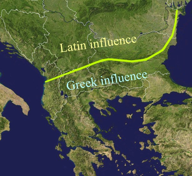
The Jirecek Line, which divides the kind of archaeological findings: to the north of the line most of the inscriptions are in Latin, to the south, they are in Greek. Aegyssos, Argamum, Histria, Tomis & Kallatis cities had greek and latin inscriptions until the VIIth cen. after JC. Jireček claimed that this line represents The division between the Greek and the Latin influence in the Balkans during the Roman Empire |
| Data | |
| Jatorria | Public domain NASA image via worldwind |
| Egilea | Bogdan Giuşcă |
| Lizentzia (Fitxategi hau berrerabiltzen) |
GFDL |

|
Baimena duzu dokumentu hau kopiatu, banatu edo/eta aldatzeko GNU Free Documentation License baldintzapean, Free Software Foundationek argitaratutako 1.2 edo ondorengo bertsioan; sekzio aldaezinik gabe, azaleko testurik gabe, eta atzeko azaleko testurik gabe. Lizentziaren kopia dago GNU Free Documentation License izenburudun atalean. |
| Fitxategi hau Creative Commons Attribution-Share Alike 3.0 Unported lizentziapean dago. | ||
| ||
| This licensing tag was added to this file as part of the GFDL licensing update. |
Fitxategiaren historia
Data/orduan klik egin fitxategiak orduan zuen itxura ikusteko.
| Data/Ordua | Iruditxoa | Neurriak | Erabiltzailea | Iruzkina | |
|---|---|---|---|---|---|
| oraingoa | 03:27, 23 otsaila 2022 | | 614 × 561 (176 KB) | Demetrios1993 | The initial version by User:Bogdan had it correct, but later, the western section of the line was altered without any justification. |
| 12:01, 25 martxoa 2018 |  | 614 × 561 (249 KB) | Trecătorul răcit | Antic shoreline and correct present-day borders | |
| 12:50, 7 abuztua 2014 |  | 614 × 561 (250 KB) | Spiridon Ion Cepleanu | According with Jirecek's works and the palaeography of Aegyssos, Argamum, Histria, Tomis & Kallatis cities (greek and latin inscriptions until the VIIth cen. after JC) | |
| 11:56, 19 apirila 2005 |  | 614 × 561 (101 KB) | Bogdan | The division between the Greek and the Latin influence in the Balkans during the Roman Empire Source: Public domain work {{GFDL}} Category:Romanian historyCategory:Roman Empire\ |
Irudira dakarten loturak
Hurrengo orrialdeek dute fitxategi honetarako lotura:
Fitxategiaren erabilera orokorra
Hurrengo beste wikiek fitxategi hau darabilte:
- an.wikipedia.org proiektuan duen erabilera
- ar.wikipedia.org proiektuan duen erabilera
- ast.wikipedia.org proiektuan duen erabilera
- ba.wikipedia.org proiektuan duen erabilera
- bg.wikipedia.org proiektuan duen erabilera
- ca.wikipedia.org proiektuan duen erabilera
- ce.wikipedia.org proiektuan duen erabilera
- cs.wikipedia.org proiektuan duen erabilera
- cv.wikipedia.org proiektuan duen erabilera
- de.wikipedia.org proiektuan duen erabilera
- el.wikipedia.org proiektuan duen erabilera
- en.wikipedia.org proiektuan duen erabilera
- es.wikipedia.org proiektuan duen erabilera
- et.wikipedia.org proiektuan duen erabilera
- fa.wikipedia.org proiektuan duen erabilera
- fr.wikipedia.org proiektuan duen erabilera
- he.wikipedia.org proiektuan duen erabilera
- hi.wikipedia.org proiektuan duen erabilera
- hr.wikipedia.org proiektuan duen erabilera
- id.wikipedia.org proiektuan duen erabilera
- it.wikipedia.org proiektuan duen erabilera
- ja.wikipedia.org proiektuan duen erabilera
- ka.wikipedia.org proiektuan duen erabilera
- ko.wikipedia.org proiektuan duen erabilera
- la.wikipedia.org proiektuan duen erabilera
- lt.wikipedia.org proiektuan duen erabilera
- nl.wikipedia.org proiektuan duen erabilera
Ikus fitxategi honen erabilpen global gehiago.